Western Mere · BreastonPlanning application summary

Outline application · PP-14459806 · Erewash Borough Council

Up to 100 new homes on the former Western Mere School site, Breaston

A 3.6 hectare brownfield plot on the north-west edge of the village. This application is the first of four phases the same applicant is promoting on adjoining land — up to 995 homes in total.

Homes proposed
Up to 100
Affordable share
45 of 100
New residents
~230 (per §2.51)
Phase
1 of 4 (up to 995 homes)
Vehicle access
Single junction on A6005
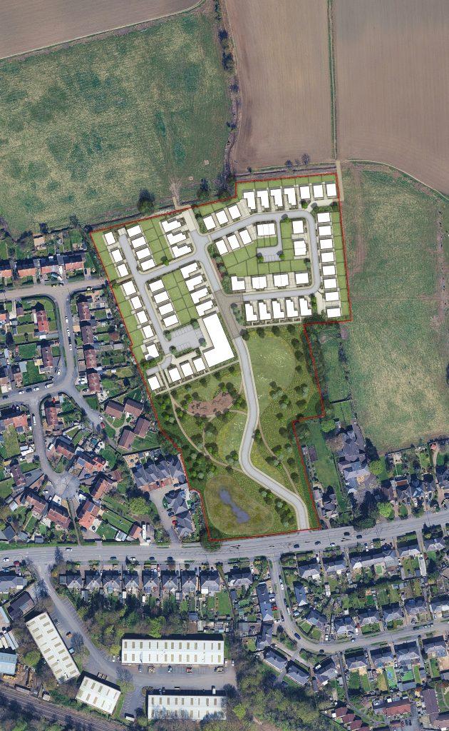
Aerial illustrative masterplan showing the proposed layout on the former Western Mere School site — homes concentrated on the northern half, a country park with attenuation pond to the south, and a single new access from Draycott Road.
Illustrative masterplan from the developer’s marketing site. Layout is a reserved matter — indicative only.

Explore by topic

What’s important to you?

Eleven topics, drawn from the application’s own documents. Pick one — or several — to read what the scheme actually says: the pros, the cons, and the gaps a careful reader can verify against the PDFs.

Nothing selected yet

Pick any chip above to open that topic. You can stack several at once if more than one matters to you — they’ll appear here in turn.

Future-proofing

What this scheme means in 30, 50, 100 years

The technical documents look at the next few years. Planning permissions, however, are effectively permanent. These four cards summarise where the application leaves the parish over a longer horizon.

Flooding under a warming climate

The drainage is designed to handle today’s worst storms plus a 40% climate allowance for the 2080s. Houses built now will be standing into the 2100s — so it matters whether the design has any room for worse rainfall to come.

  • The pond has 34 cm of spare height above the 1-in-100-year storm. Adequate today, tight if the future revises upwards.
  • Flood depths nudge up by ~25 mm just east of the site in extreme storms. The applicant owns that land — for now.
  • The site sits on ground that’s very prone to groundwater flooding. No tests for this have been done yet.
  • Golden Brook, a Main River 180 m east, sits outside the flood model.

Wildlife over the next 30 years

The law requires habitats to be left at least 10% better off, with care taken for 30 years. This scheme clears the 10% bar by just 0.35 of a percentage point — and the gain depends on hedgerows and trees that take decades to mature.

  • Every large tree on site is removed. 118 new saplings replace them — but it’ll be 20–30 years before they catch up.
  • Garden planting and ornamental hedges count toward the gain. Their actual value depends on individual homeowners.
  • The baseline was measured in a single July visit. Proper grassland surveys need visits across the year.
  • No named body, no funding, and no legal agreement is in place to deliver the 30-year promises.

Heating bills and net zero

Homes built today have to last to net zero in 2050 and beyond. The scheme is designed against the 2021 building rules — not the newer Future Homes Standard that applies from 2025.

  • Heat pumps are proposed instead of gas boilers — a real plus.
  • Solar panels appear to go only on 2-bed homes; bigger homes get heat pumps but no panels. The split needs confirming.
  • No overheating check has been done. That’s left to a later stage.
  • Electric-car charging is mentioned but not specified — no spaces-per-home or charger power.

Pressure on local services

This is the first of up to 995 homes the same applicant wants to build around Breaston. Even on its own it adds ~10% to the village stock. Consultation raised GP, school and traffic capacity — the application offers money but not evidence those services have room.

  • Money is offered for primary, secondary and SEND school places and healthcare — but no proof the receiving schools and GP surgery have space.
  • Other planned developments in the area aren’t included in the traffic model.
  • Bostock’s Lane junction is already well over capacity. No fix is offered.
  • The most common consultation request — bungalows for older residents — isn’t in the indicative housing mix.

Planning policy context

The policy ground has shifted under this application

Planning applications are tested against the development plan for the area and any other material considerations, with the National Planning Policy Framework (NPPF) at the centre. The most important fact about this application is that it was submitted into a policy gap.

The Erewash Core Strategy — Erewash’s adopted local plan — was withdrawn on 22 January 2026, about three months before the application was made. The Core Strategy Review that was meant to replace it had already been identified by the Planning Inspectorate as having significant soundness concerns — on spatial strategy and settlement hierarchy, housing requirement and housing supply, and Green Belt assessment and site selection (Inspector’s letter dated 20 November 2025) — and was subsequently withdrawn.

In the absence of an up-to-date plan, the NPPF’s “tilted balance” (paragraph 11(d)) usually presumes in favour of sustainable development — but NPPF footnote 7disapplies that presumption where the proposal is in a protected area, including the Green Belt. The application’s central claim is therefore that the site qualifies as “grey belt” under paragraph 155, which would re-engage a more permissive test.

The remaining bits of the planning policy framework that the council and any inspector can rely on are the NPPF itself (December 2024), the saved Erewash Local Plan policies from 2005 (amended 2014), and any supplementary planning documents that are not contingent on the withdrawn Core Strategy.
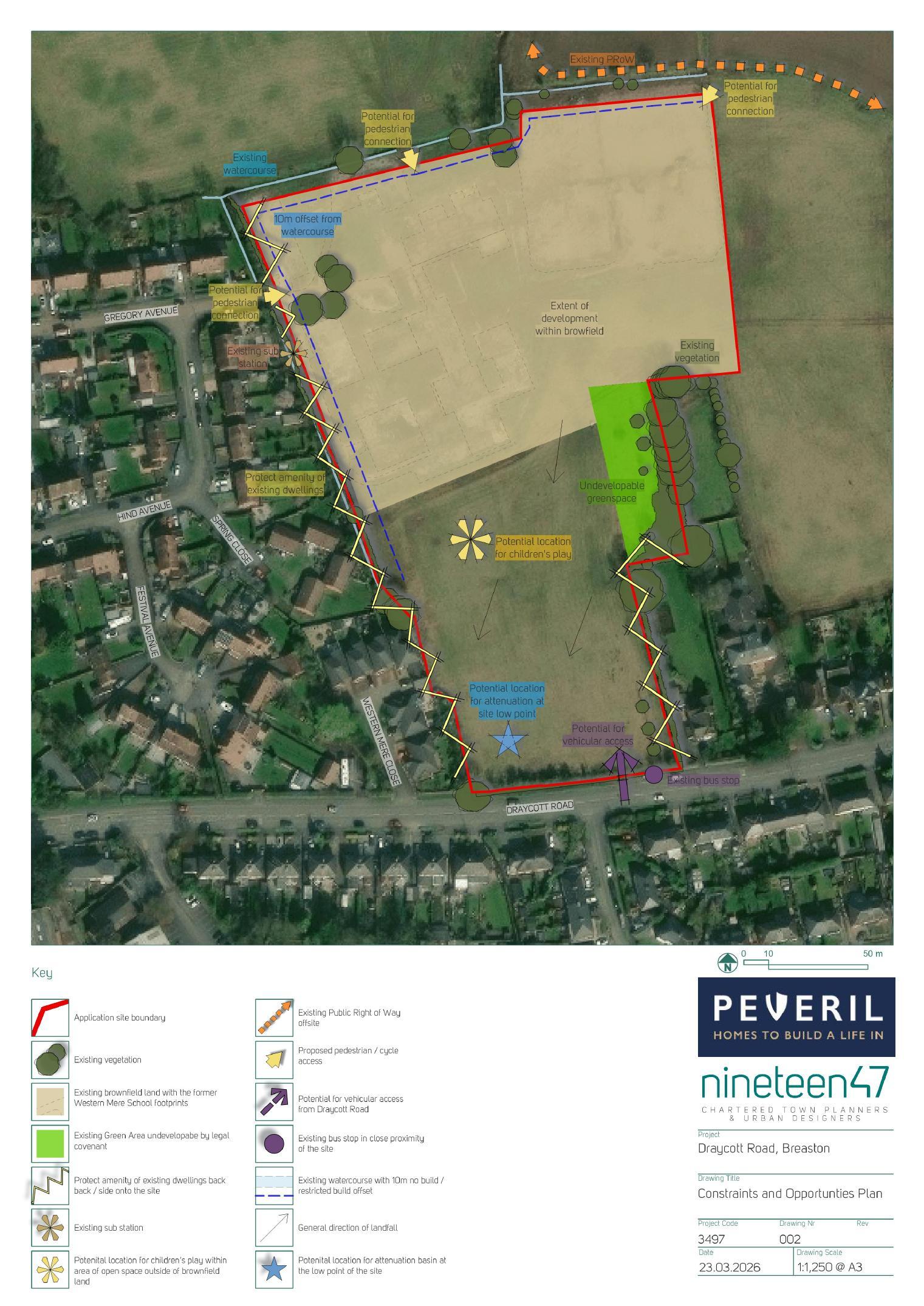
Constraints and opportunities plan showing the Green Belt boundary, Breaston Conservation Area boundary, public rights of way, watercourses and trees on or around the site.
Constraints & Opportunities Plan. Source: application drawing ref 3497-002.

Procedural review

Procedural issues with the application

These are the procedural points a planning officer or parish councillor would want to scrutinise — reliance on withdrawn policies, capacity checks done at the wrong unit count, numbering errors, document inconsistencies. Open any card to see the exact passage from the applicant’s own documents and jump straight to the source PDF.

  • 3Critical
  • 5Worth scrutinising
  • 3Observation
  1. 01Critical

    The case is built on a plan that no longer exists

    Erewash scrapped its local plan on 22 January 2026 — three months before this application was submitted. The applicant still cites 13 of its policies as if they were live, including the one used to justify the 45% affordable-housing offer.

    See the wording from the document· 4 passages
    1. Planning Statement — Section 3 (Planning Policy Context)

      Lists the following Erewash Core Strategy policies as the basis for assessment: Policy A (Presumption in favour of Sustainable Development); Policy 1 (Climate Change); Policy 2 (Spatial Strategy); Policy 3 (Green Belt); Policy 8 (Housing Size, Mix and Choice — 30% affordable trigger); Policy 10 (Design); Policy 11 (Historic Environment); Policy 12 (Education); Policies 14 & 15 (Travel); Policy 17 (Biodiversity); Policy 18 (Community Halls); Policy 19 (Developer Contributions).
      Open source PDF
    2. Planning Statement §3.85 (and §§3.86–3.90, 4.55–4.75)

      §3.85 confirms the Erewash Core Strategy Review was withdrawn on 22 January 2026. §§3.86–3.90 and §§4.55–4.75 then deploy that withdrawal in support of the housing-supply and tilted-balance case, rather than re-testing the proposal against the resulting policy vacuum.
      Open source PDF
    3. Planning Statement §2.46 (Policy 19) and §§2.48–2.56 (S106 Heads of Terms)

      §2.46 quotes Core Strategy Policy 19 (Developer Contributions) as the framing policy; §§2.48–2.56 then enumerate the S106 Heads of Terms (education, healthcare, libraries, travel-plan monitoring, open-space management, BNG monitoring fee) on that basis. The Core Strategy was withdrawn before the application was submitted.
      Open source PDF
    4. Planning Statement §§2.57–2.58 and §3.57 (Affordable Housing)

      Derives the 45% affordable-housing offer (the 'Golden Rules' uplift) from a 30% baseline taken from withdrawn Core Strategy Policy 8. The 80/20 social-rent/shared-ownership tenure split is then set out at §2.59.
      Open source PDF
  2. 02Critical

    This is Phase 1 of up to 995 homes on adjoining land

    The same applicant is promoting 85.61 hectares around Breaston for up to 995 homes across four phases (Phase 1: 110 · Phase 2: 345 · Phase 3: 350 · Phase 4: 190). This application is for up to 100 dwellings within the Phase 1 footprint. Granting permission here sets the precedent for the rest.

    See the wording from the document· 2 passages
    1. Planning Statement Figure 6 and §3.79 (page 32)

      Figure 6 shows the wider 85.61 ha promotion submitted to the Council's 2024 call-for-sites; §3.79 gives the headline yields by phase — Phase 1: 110 dwellings (6.96 ha, 4.58 ha net); Phase 2: 345; Phase 3: 350; Phase 4: 190 — totalling 995 across the four phases. The current application is for up to 100 dwellings within the Phase 1 footprint.
      Open source PDF
    2. Planning Statement §4.73 — Strategic Policy 1.7 / West of Sandiacre

      §4.73 explains that the previous (withdrawn-plan) Strategic Policy 1.7 allocation 'West of Sandiacre' — another site in the same applicant's ownership — was promoted at 180 dwellings, which the applicant now considers untested; 100 dwellings is described as 'more realistic'. Useful corroboration that earlier borough-wide capacity figures were optimistic, although it relates to a different Peveril Homes site rather than the Breaston Phase 1 itself.
      Open source PDF
  3. 03Critical

    The sewer capacity check covers 75 homes, not 100

    Severn Trent has only checked that the local sewer can take 75 new homes. The application proposes up to 100. Capacity for the extra 25 has not been demonstrated.

    See the wording from the document· 3 passages
    1. Flood Risk Assessment §2.4

      Describes the proposed development as "circa 75 dwellings".
      Open source PDF
    2. Severn Trent Pre-development Enquiry (FRA Appendix B, ref 1164669, 19 Nov 2025)

      Severn Trent's capacity check is sized on "65 Dwellings and 10 Flats — 1.17 l/s" at 2× dry weather flow — i.e. for 75 units, not the up-to-100 envelope of the planning application.
      Open source PDF
    3. Flood Risk Assessment §7.2

      Confirms the connection is to a 225 mm Severn Trent combined sewer in Draycott Road via a new manhole between existing MHs Ex 3401 and Ex 4401. The downstream hydraulic capacity of that combined sewer is not modelled in the application.
      Open source PDF
  4. 04Worth scrutinising

    The wildlife improvements only just clear the legal floor

    The law requires new developments to leave wildlife habitat at least 10% better off. This scheme reports 10.35% — a margin of just 0.35 of a percentage point. Any habitat that fails to establish would drop the scheme below the legal minimum.

    See the wording from the document· 3 passages
    1. Biodiversity Net Gain Report Figure 3 (Final Results), page 8

      Area habitat units: 7.86 baseline → 8.67 post-development → +0.81 (+10.35%). Statutory minimum is +10%. Margin above the legal floor is therefore 0.35 percentage points.
      Open source PDF
    2. Biodiversity Net Gain Report — Methodology, page 2

      Habitat field survey conducted on a single visit on 7 July 2025. Best practice under Defra's Technical Annex 1 is for grassland condition to be assessed across multiple visits over the April–September growing season.
      Open source PDF
    3. Biodiversity Net Gain Report §8.3 — Recommendations

      Recommends that a Habitat Management and Monitoring Plan (HMMP) be prepared, but does not name the responsible body, funding mechanism, conservation covenant or financial bond that will secure the 30-year obligation.
      Open source PDF
  5. 05Worth scrutinising

    Bostock’s Lane junction is already over capacity

    Bostock’s Lane mini-roundabout is already running well over capacity in 2025 — and the development would make it worse. No improvements are proposed.

    See the wording from the document· 3 passages
    1. Transport Assessment §6.9–6.10 — Bostock's Lane mini-roundabout

      ARCADY modelling for the worst-case arm (Bostock's Lane): 2025 observed RFC 144% AM / 149% PM; 2031 base 153% / 159%; 2031 with development 153% / 162%. Longmoor Road West: 2025 102%/98%; 2031 base 109%/105%; 2031 with development 111%/106%. Development adds 17 AM Longmoor West and 15 PM Bostock's Lane trips.
      Open source PDF
    2. Transport Assessment §6.10 — Conclusion

      Concludes the impact is "not severe" and proposes no mitigation, noting that ARCADY over-estimates queues at this junction compared with observed conditions.
      Open source PDF
    3. Transport Assessment §5.4 — Committed developments

      Asserts "There are no other committed developments in Erewash district that would directly increase traffic flows at the study area junctions." Cumulative impact is therefore captured only via 1.06× TEMPro background growth — no named committed schemes are listed.
      Open source PDF
  6. 06Worth scrutinising

    One way in, one way out — for 100 households

    All vehicles use a single new junction onto Draycott Road. If it’s blocked by an accident or roadworks, the estate is cut off. No emergency-only second access is described.

    See the wording from the document· 3 passages
    1. Transport Assessment §3.6 — Site access design

      Describes a single priority T-junction with ghost-island right-turn lane off the A6005 (DMRB CD123, design speed 50 kph). 2.4 m × ~57 m visibility splays. No secondary or emergency vehicular access is described.
      Open source PDF
    2. Proposed Site Access Layout drawing 3594-ADC-HGN-XX-DR-CH-0101-S1-P04

      Drawing covers only the A6005 frontage. The Gregory Avenue boundary mechanism — bollards, drop-bollards for fire service, gates, refuse-vehicle access — is not specified.
      Open source PDF
    3. Travel Plan §3 (Illustrative Masterplan, Appendix A)

      Shows the internal layout connecting only to the A6005, with the Gregory Avenue boundary occupied by a landscaped buffer — implying pedestrian/cycle permeability only by design, but no explicit text on the emergency-access arrangement.
      Open source PDF
  7. 07Worth scrutinising

    The public consultation drew 26 responses

    From a parish of around 4,200 people, just 26 wrote in during the 6-week pre-application consultation. The applicant describes 10 of those as supportive. No scheme changes are listed as a result.

    See the wording from the document· 3 passages
    1. Statement of Community Involvement, Chapter 6, page 9

      Records 26 written feedback-form responses received during the 6-week consultation (8 January – 26 February 2026). The Planning Statement characterises 10 of those as supportive ("over a third").
      Open source PDF
    2. Statement of Community Involvement, Chapter 6 — Top concerns

      Top resident concerns: pressure on GP / healthcare provision; school place capacity; flooding; highways / traffic / road safety; design and character; demand for bungalows for residents with mobility needs (8 of 26 — the largest single specific request); and in-principle opposition (6 of 26 said no need for housing).
      Open source PDF
    3. Statement of Community Involvement, Chapter 7 — Conclusion, page 11

      States only: "For a fuller outline of how this consultation has influenced the wider proposal, please see the rest of the planning application." No "you said, we did" table; no scheme amendments attributed to consultation feedback.
      Open source PDF
  8. 08Worth scrutinising

    Five protected trees would be felled

    Five trees protected by a 1993 Tree Preservation Order would be cut down: an ash and four birches. A section of the non-TPO roadside hedgerow goes too, for the new junction. Replacement planting is promised in principle, not specified.

    See the wording from the document· 3 passages
    1. Arboricultural Impact Assessment §4.2 — Tree removal table

      Trees to be felled to enable development include: T055 (ash, TPO, Category B1); T065 (birch, TPO, C1); T066, T067, T068 (birches, TPO, B1); plus a section of H004 (Category B2 roadside hedgerow, not TPO) — sectionally felled for the new highways access. Three additional U-category trees (T003, T015, T016) are recommended for felling on condition grounds (AIA Method Statement §5.2).
      Open source PDF
    2. Arboricultural Impact Assessment §6.1, §3.20 — Summary

      Confirms five TPO trees in total are lost as a result of the scheme. The 1993 Former Western Mere School TPO is identified as the primary order covering the site. The TPO-protected hedgerow on the western boundary (H064) is retained; the hedgerow section being lost is H004 on the Draycott Road frontage, which is not TPO-protected.
      Open source PDF
    3. Arboricultural Impact Assessment §6.2 — Mitigation

      Commits to "significant new tree planting measures… can include robust, semi-mature replacements for protected trees" — but provides no species schedule or numbers at outline stage.
      Open source PDF
  9. 09Observation

    Different documents give different site sizes

    The application form says 3.975 ha, the flood risk assessment says 3.6 ha, the design statement 3.57 ha, the geo-environmental report 3.56 ha and the hydraulic model 3.4 ha. The site's name also varies — including 'Weston Mare School' on the existing substation signage.

    See the wording from the document· 6 passages
    1. Application Form — Site Area box

      Site area stated as 3.975 hectares.
      Open source PDF
    2. Flood Risk Assessment, p.3

      Site area described as "approximately 3.6 hectares (ha)".
      Open source PDF
    3. Design & Access Statement, page 33

      Gross site area (red-line) given as 3.57 hectares / 8.81 acres. Residential developable area 2.29 ha; open space 1.28 ha.
      Open source PDF
    4. Phase 1 Geo-Environmental Assessment, Table 2.0

      Site area stated as 3.56 hectares.
      Open source PDF
    5. Hydraulic Modelling Study Table 1-1

      Site area stated as 3.4 hectares.
      Open source PDF
    6. Phase 1 Geo-Environmental Assessment, p.3, p.8

      Cover title: "Site to East of Gregory Avenue, Breaston". Site referred to internally as "Weston Mere County Secondary School". The existing on-site substation signage reads "Weston Mare School Breaston" (note 'Mare').
      Open source PDF
  10. 10Observation

    The energy report has a different site’s name on its main table

    The carbon-savings table in the Energy Statement is titled ‘Development at Larch Drive, Sandiacre’ — a different scheme. The numbers may be correct for Breaston, but the labelling makes that hard to confirm.

    See the wording from the document· 2 passages
    1. Energy & Sustainability Statement — Appendix A, page 22

      Titled "Development at Larch Drive, Sandiacre" — appears to be a copy-paste from a different scheme. Spreadsheet dated 06/11/2025, three months before the Energy Statement's cover-page date of 3 February 2026.
      Open source PDF
    2. Energy & Sustainability Statement §10.6

      Performance is modelled against Approved Document L 2021 (claimed 61.9% CO₂ reduction). The Future Homes Standard (which is the prevailing standard for homes built from 2025 onward) is referenced only as "current Part L / 'future homes' requirements" and is not modelled.
      Open source PDF
  11. 11Observation

    Flood depths would rise slightly on land east of the site

    The applicant’s flood modelling shows roughly 25 mm more flood water in a small area just east of the site in extreme storms. The applicant owns that land too, so they call it acceptable — but if that land is sold later, the higher flood baseline is locked in.

    See the wording from the document· 2 passages
    1. Hydraulic Modelling Study §5.3.6 / Figure 5-11

      Reports a "moderate increase" in flood depths of approximately +25 mm in a small area immediately east of the site, north of Draycott Road, in the 1% AEP + 40% climate-change event. Baseline depths at that location are ~250 mm, so the relative increase is around 10%.
      Open source PDF
    2. Hydraulic Modelling Study §10 — Conclusions

      JBA argue the increase falls within Peveril Homes' wider ownership boundary and that the dominant flood source at that point is Golden Brook (which sits outside the modelled extent). Concludes "no adverse flood risk impact to third-party land".
      Open source PDF

The source documents

Read it for yourself

Every claim on this site links back to one of the documents below. PDFs open in a new tab.

Application

  • Application Form

    The submitted planning portal application form (PP-14459806). States the site area as 3.60 ha, last use as Western Mere County Secondary School (ceased 1 Jan 1990), proposes 200 car / 100 cycle spaces, foul drainage to mains sewer, surface water via SuDS + mains sewer, pre-development biodiversity value of 7.86.

    Open PDF
  • Open PDF

Planning

  • Planning Statement

    Thornton Planning Limited · March 2026

    Headline planning case. Argues the site qualifies as ‘grey belt’ under NPPF para 155; cites the failed 2023 Housing Delivery Test (67%) and the absence of a 5-year housing land supply; relies extensively on the now-withdrawn Erewash Core Strategy; offers 45% on-site affordable housing under the ‘Golden Rules’; and sets out S106 heads of terms across education, healthcare, libraries, travel plan and open-space management. 68 pages.

    Open PDF

Design

  • Design & Access Statement

    Nineteen47

    Rationale for the indicative masterplan: density, character zones, parking strategy, indicative dwelling mix and landscape-led approach.

    Open PDF

Heritage & Landscape

Ecology

  • Biodiversity Net Gain Report

    Estrada Ecology Ltd · 2 December 2025 · SQ-3486.B

    Headline 10.35% on-site habitat net gain, 69.88% hedgerow net gain. Single July 2025 survey visit. No protected-species results are presented in this report.

    Open PDF
  • Biodiversity Net Gain Metric (spreadsheet)

    The Defra statutory-metric calculation tool. Holds the underlying distinctiveness, condition, strategic-significance and risk-multiplier inputs from which the headline net-gain figures are derived.

    Open PDF

Flood & Drainage

  • Flood Risk Assessment & Drainage Strategy

    BMc Engineering · 20 November 2025 · 25018-BMC-25-XX-RP-C-001

    Site in Flood Zone 1. Post-development discharge restricted to 13.7 l/s into Golden Stream. 1,356 m³ attenuation pond. Severn Trent pre-development enquiry for foul drainage sized on 75 units rather than the up-to-100 application.

    Open PDF
  • Hydraulic Modelling Study

    JBA Consulting · 13 November 2025 · PSL-JBA-XX-XX-RP-HM-0001

    1D-2D ESTRY-TUFLOW direct-rainfall model of Golden Stream and tributary ditches. Finds a ~25 mm flood-depth increase east of the site (north of Draycott Road) in the 1% AEP + 40% CC event. Golden Brook is outside the model extent.

    Open PDF

Transport

  • Transport Assessment

    ADC Infrastructure · March 2026 · ADC3594-RP-D

    61 two-way vehicle movements predicted in peak hours. Site access modelled within capacity. Eaton Farm roundabout reaches 95% RFC. Bostock’s Lane mini-roundabout already over capacity at 144–162% with no mitigation proposed.

    Open PDF
  • Travel Plan

    ADC Infrastructure · January 2026 · ADC3594-RP-C

    Targets a 10-point reduction in car-driver modal share (57% → 47%) by end of monitoring period. Travel Plan Coordinator, welcome packs, bus-taster vouchers up to £100 per dwelling, 5-year monitoring via Modeshift STARS.

    Open PDF

Energy & Sustainability

  • Energy & Sustainability Statement

    Energy & Design · 3 February 2026

    Modelled 61.9% CO₂ reduction below Part L 2021. Air Source / Ground Source Heat Pumps proposed; PV on 2-bed plots only. Water target ≤105 l/p/d. Appendix A inadvertently titled ‘Larch Drive, Sandiacre’.

    Open PDF

Ground

  • Phase 1 Geo-Environmental Assessment

    Elemental GI Ltd · E24151

    Desk-based assessment. No coal/mining issues, Radon Class 1. Asbestos in existing substation; historic 1982 tank on site. Multiple low/moderate human-health risk pathways pending Phase 2 intrusive investigation, which is deferred to a planning condition.

    Open PDF

Community

  • Statement of Community Involvement

    Calcomms · March 2026

    8 January – 26 February 2026 digital-led consultation. 26 feedback responses received. Top concerns: GP/healthcare, school capacity, flooding, highways. No public exhibition held; no ‘you said, we did’ table provided.

    Open PDF

Drawings